Article
Indoor Navigation Solutions: Guiding Users Through Complex Spaces

September 3, 2025 ...

What is indoor navigation?
Indoor navigation—enabled via sensor fusion, Internet of Things (IOT) integration, and user-facing applications—focuses on a central goal: helping people find their way through complex buildings including airports, malls, hospitals, corporate campuses, and stadiums. By providing their customers and patrons with digital indoor maps, mobile apps to access them, and accurate location-based services, smart building owners can provide real-time navigation services while also tapping into virutally limitless data-driven insights.
At its core, indoor navigation acts as analog to outdoor GPS. The necessity for reliable indoor wayfinding lies in the fact that GPS is satellite‑based and works best outdoors, making it less reliable in buildings where clear satellite signals are weak or unavailable.
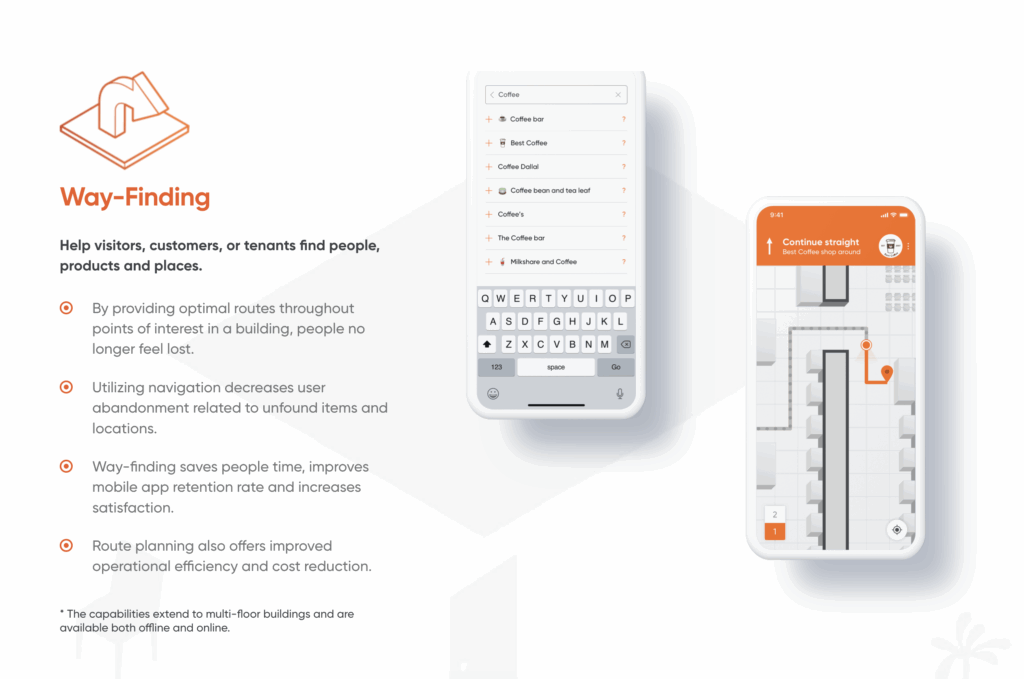
Through a combination of indoor positioning systems (IPS), cloud-based mapping, and intelligent software, indoor wayfinding provides turn-by-turn guidance, enhances user experience and building accessibility, and unlocks opportunities for businesses to understand how people move through their spaces.
The evolution of indoor navigation and wayfinding solutions
For much of our human history, indoor wayfinding solutions were as simple as following physical signs through various architectural layouts, or with the help of building staff. From the streets of Roman cities to corridors of medieval castles, from the hallways of school houses to the vertical space in modern office towers, humans have long-relied on physical signage to find their ways through space.
Early outdoor methods of navigation like dead reckoning—a technique where a position is estimated via the relationship between starting point, speed, direction, and time—were extended from ancient seafaring to the modern day. And, dead reckoning is still used today, from robots navigating warehouses without GPS to pilots maintaining course during a signal loss and autonomous vehicles traveling through tunnels or dense cityscapes. It’s still used often as a fallback when external signals are unavailable, illustrating the interconnectedness between solutions of the past and the methods of indoor mapping used today.
But, as our technological capabilities have rapidly advanced with AI, AR, IoT, and numerous other innovations, traditional methods have set the stage for sophisticated alternatives:
- A confluence of real-time sensors, wireless networks, and intelligent algorithms,
- That when combined, enable precise, dynamic indoor navigation that extends upon what was possible with earlier methods
What were the key drivers of the evolution of indoor wayfinding technology?
Foundational Indoor Navigation Research (1960s–2000s)
Thought leadership during this time period focused on urban studies and the psychology of navigation and architecture, as well as concepts like imageability and legible space. However, technology lagged behind human cognitive navigation models.
For more on this period, see Hassan A. Karimi’s collection, “Indoor Wayfinding and Navigation.”
Hardware-based Breakthroughs (2000s–2010s)
- BLE beacons emerged as a practical way to create location-aware smartphones. Apple’s protocol—iBeacon unveiled in 2013—accelerated mainstream adoption
- Wi-Fi positioning and RFID tagging allowed navigation based on varying signal strengths
- These systems transformed smart buildings into smart spaces, but the costs and maintenance of infrastructure and integration slowed widespread use
Smart Software and Hardware Integration (2016–Present)
- Sensor fusion technology combines various technologies including motion sensors, cameras, and wireless signals, for a range of use cases, from smart agriculture to space
- Geomagnetic positioning—leveraging a building’s unique magnetic field signature—offers hardware-free deployment.
- Cloud-based mapping platforms offer precision, as well as automated cloud-based updates for scalable deployment.
- New drivers—from IoT integration in smart buildings to demand for personalized experiences—are reshaping both user expectations and technical requirements.
The current state of the indoor wayfinding industry
Grand View Research reports that “The global indoor positioning and navigation market size was estimated at USD 20.38 billion in 2023 and is projected to reach USD 174.02 billion by 2030, growing at a CAGR of 37.6% from 2024 to 2030.”
Growth is fueled by advanced smart building navigation, location-based services, and the rising need for enterprise system integration and analytics.
Today, solutions fall into distinct categories:
- BLE beacons: Still common but require physical installation and upkeep.
- Wi-Fi positioning: Useful where Wi-Fi is already dense, though it can suffer from interference and/or limited accuracy.
- Ultra-wideband (UWB) positioning: Offers centimeter-level accuracy for critical use cases (e.g. industrial logistics in factories) but is limited by hardware cost.
- Geomagnetic positioning: Hardware-free, scalable, and increasingly used for large venue mapping solutions.
- Computer vision & AR wayfinding: Supports advanced features such as augmented reality wayfinding overlays and 3D indoor mapping
- Hybrid, sensor-fusion approaches: Combine multiple signals to drive positioning accuracy and reliable cloud-based mapping across multi-floor and complex facilities.
Leaders in the space (GoodMaps, Navigine, MapsIndoors, beComap, Cisco Spaces, IndoorAtlas, Mapsted, Atrius, etc.) use combinations of the aforementioned technologies to bring their solutions to life.
Challenges and barriers to implementing indoor mapping solutions — and how to overcome them
Challenges and Barriers
While the technology has matured, adopting today’s indoor mapping and wayfinding solutions still comes with challenges:
- Hardware dependency & cost: Infrastructure (beacon and RFID) can be expensive and require routine calibration.
- Scalability: Multi-floor navigation and large venues can expose weaknesses in Wi-Fi or Bluetooth systems.
- Integration complexity: Consistency across different building materials, layouts, and IT systems remains difficult.
- User experience hurdles: Usability and performance are top priorities; digital indoor maps must match user expectations (similar to outdoor maps) to ensure adoption.
- Privacy and security compliance: Gathering user data requires strict adherence to global regulations like GDPR.
- Awareness of the possibilities and need for proven ROI: Decision-makers may still hesitate, due to unclear cost-benefit evaluations.
Six Requirements to Overcome Challenges
Organizations looking to adopt indoor navigation solutions should ensure they:
- Create accurate digital indoor maps of their spaces.
- Select technologies for positioning accuracy (BLE, Wi-Fi, UWB, geomagnetic) aligned with their infrastructure, budget, and technological capabilities
- Deploy scalable software platforms that enable real-time route optimization and integrate into enterprise systems
- Follow strict privacy and security compliance guidelines
- Prioritize user experience with intuitive, accessible interfaces
- Weigh hardware investments carefully (leaning toward scalable and hardware-minimal options)
For complex indoor spaces, user-friendly indoor navigation solutions are a must-have
From simple wayfinding signs to advanced, AI-powered mapping solutions, indoor navigation solutions have advanced significantly. With an invisible connective network that bridges the gap between digital data and physical experiences, this technology has transformed how people interact with buildings.
For enterprises, the benefits of smart building navigation optimize space usage to enhancing customer satisfaction and accessibility. As smart buildings, public venues, retail environments, and any other indoor physical space that could benefit from digital transformation, businesses across the spectrum can invest not only solve immediate indoor navigation challenges but position themselves to deliver seamless experiences that existing and future customers will expect.
All signs point to an ongoing proliferation of cloud-based mapping platforms, real-time navigation, navigation analytics, and richer location-based services. It’s up to businesses to break trail in this new frontier of connected, intelligent spaces. If you’re looking for guidance in getting starting, let’s sync to discuss your opportunity.